_edited.jpg)
Help test a new spatial data tool for biodiversity projects
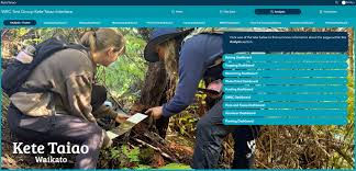
Waikato Regional Council is piloting a new spatial data management tool designed to support community-led biodiversity projects.
Kete Taiao Waikato can be used on desktop or mobile to record things like planting, pest control (animals and plants), monitoring and volunteer hours, all in one place.
It works in the field and makes it easier to plan activities, track progress, and report on what’s being achieved.
Click here to watch a short demo of what can be done.
If you're interested in being a pilot group for Kete Taiao Waikato, WRC would love to hear from you. They're looking for groups who are:
comfortable using technology (or keen to learn)
willing to actively use the tool and provide feedback
able to put some time into learning and using the system as part of their project work
positive about helping test the tool so it works well for community groups.
Please email WRC directly including your group name, a contact person, and a short description of your project to ketetaiao@waikatoregion.govt.nz.
Comments